A Fire on Raven Ridge: A Case for Decentralized Wildfire Response
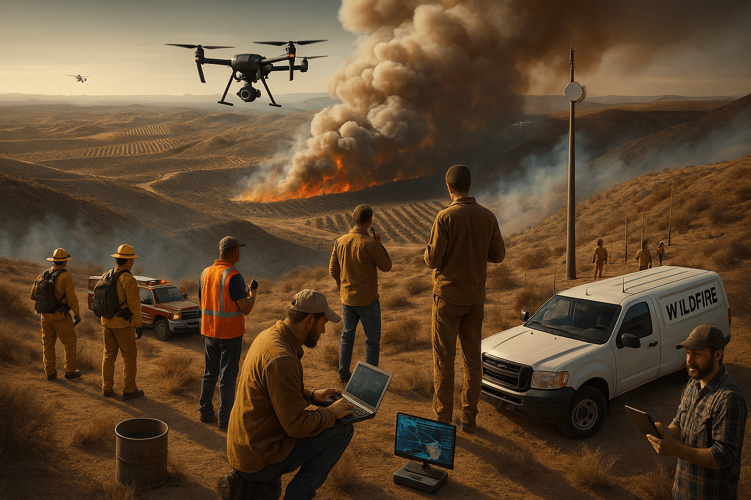
The late summer sun hung low over Raven Ridge, casting long shadows across the dry brushland. It had been an unusually hot season, and the ridge—a well-known fire-prone area at the edge of the Wildland-Urban Interface (WUI)—had become a tinderbox. Around 3:12 PM, a wisp of smoke appeared near a cluster of trees along a hiking trail. The AI-driven wildfire detection cameras stationed on the ridge’s outskirts identified the smoke within seconds and flagged the anomaly to the 24/7 Command Center operating 20 miles away.
Since this framework was first published in January 2025, several developments have reinforced the case for decentralized wildfire response:
The January 2025 Los Angeles wildfires — the Palisades and Eaton fires — destroyed over 16,000 structures, killed 31 people, and forced 200,000+ evacuations. LA County’s after-action report (September 2025) found no single point of failure but rather a series of systemic weaknesses: outdated evacuation policies, communication gaps between agencies, and staffing shortfalls that left initial response overwhelmed. These are precisely the coordination failures a decentralized framework aims to mitigate.
In June 2025, the U.S. Government Accountability Office testified before Congress on wildfire management technologies, highlighting AI-powered cameras, drone ISR, IoT sensor networks, and satellite imagery as critical enablers — all core components of the framework proposed here. Meanwhile, startups like Dryad (ground-sensor IoT networks) and FireSwarm Solutions (autonomous water-dropping drones carrying 400kg payloads) continue advancing the technological capabilities this model depends on.
The LA response also demonstrated the raw power of community mobilization — over 30,000 volunteers activated within the first month — while simultaneously exposing the absence of the kind of structured, app-coordinated citizen auxiliary system described below.
Original article follows with structural and editorial updates applied.
Early Detection and Activation
Sitting at her workstation, Lia, a Command Center operator, received the alert. The system’s algorithm confirmed it wasn’t a false alarm, cross-referencing the camera footage with environmental data from nearby IoT sensors. A notification was immediately dispatched to local professional firefighting crews, now en route to the suspected blaze. Lia also accessed the network of registered citizen volunteers in the area. Among them was Ethan, a trained drone operator, who lived less than three miles from the smoke’s location.
Ethan’s phone buzzed with a notification: “Potential fire detected near Raven Ridge. Are you available to assist?” He tapped “Yes” on his app, and within moments, the command center sent him coordinates for a safe staging area. As he readied his drone, the app displayed key information: the prevailing wind direction, safe operational altitudes, and a caution to clear the airspace immediately if the aircraft approached. He grabbed his gear and headed to the designated site.
The First Flyover
Ethan arrived at the staging area and launched his quadcopter. The drone climbed steadily, its onboard camera feeding live video directly to the command center. Lia patched the feed from her station into the SITEMP-like tactical map, overlaying it with real-time weather data from IoT sensors installed by other citizen participants in the area. The sensors confirmed erratic gusts of wind blowing toward a small neighborhood on the ridge’s western slope.
“Ethan, redirect your drone to the southern perimeter of the smoke,” Lia instructed through the app’s communication feature. “We need a clearer view of the fireline forming there.”
Ethan adjusted the drone’s trajectory, sending the live feed of flames licking at the brush’s edge. He kept the drone upwind, ensuring it stayed clear of smoke turbulence. Lia marked the fireline’s location on the tactical map at the command center and relayed the information to the professional crews now closing in on the scene.
Citizen-Led Initial Mitigation
Meanwhile, a group of volunteers stationed on the ridge’s northern side received their alerts. Among them was Carla, who managed a cache of hand tools stored at a community center. Guided by risk-assessed instructions from the command center, Carla and her team retrieved fire rakes, shovels, and protective gear. The app provided directions to a safe location for starting a firebreak well ahead of the advancing flames.
As Carla and her team worked, the app tracked their geolocation and monitored environmental conditions in real-time. A weather sensor less than a mile away detected a sudden drop in humidity and increased wind speed. Lia’s screen flashed a warning: the fire might accelerate.
“Carla, this is Command. Wind speeds are picking up. You’ve got about 15 minutes before it’s unsafe to stay in that area. Begin wrapping up and prepare to evacuate.” Carla acknowledged the message, urging her team to complete the firebreak and retreat to their vehicles.
Professional Crews Take Over
By the time the professional firefighting crews arrived, the citizen teams had cleared the area, and Ethan’s drone was safely grounded to make way for a water-dropping aircraft. The command center shifted its role, transferring authority to the arriving incident commander on the ground. The continuous data streams from the drone, IoT sensors, and geotagged citizen reports remained available for the crews’ use, displayed on tablets carried by the team leaders.
The tactical map provided critical insights: the exact fireline location, the completed firebreak, and weather conditions. Using this data, the professional crews devised a strategy to contain the blaze before it reached the neighborhood. Their coordinated attack, supported by precise situational awareness, successfully halted the fire’s advance within hours.
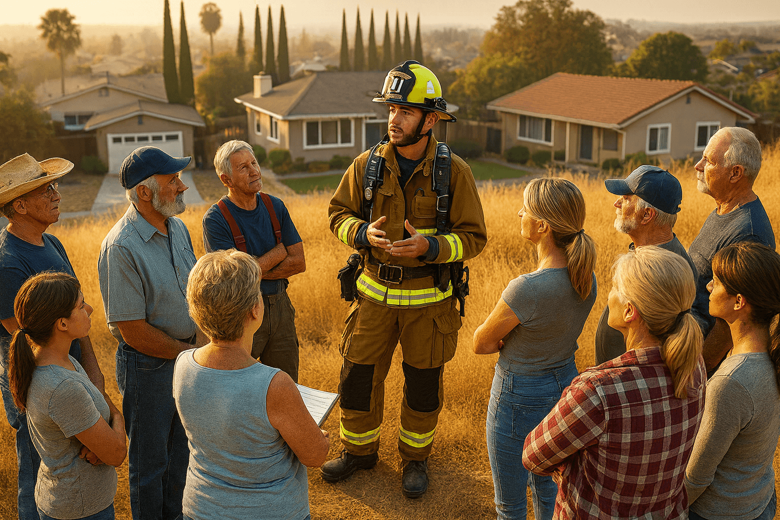
As the professional teams took over suppression efforts, the volunteers pivoted to preemptive evacuation assistance for nearby residents. Guided by the app’s dynamic evacuation routes and real-time fire progression data, the auxiliary participants moved door-to-door, alerting households and directing them to safety. The command center monitored the volunteers’ geolocations and ensured they operated only within safe zones, updating routes as conditions changed.
This effort significantly freed up first responders’ limited resources, allowing fire crews to focus entirely on containment and suppression. By handling evacuations and logistical support, the volunteers enabled professional teams to direct their attention and expertise where it was needed most, ensuring a more effective and coordinated response to the fire.
From Scenario to Framework
The fictional Raven Ridge incident illustrates the potential of a decentralized wildfire response framework in action. It showcases how community volunteers, equipped with advanced tools and guided by a command and control system, can swiftly mitigate risks and support professional firefighting efforts. By integrating real-time intelligence, leveraging local knowledge, and utilizing cutting-edge technology, this model enhances situational awareness and optimizes resource allocation. The following sections delve into the conceptual framework, its technological underpinnings, and its critical role in augmenting state and federal wildfire management strategies, providing actionable insights for implementation and scalability.
Introducing the Decentralized Wildfire Framework
The Raven Ridge response clearly demonstrates how a decentralized wildfire framework empowers local communities to complement professional firefighting efforts. At the heart of this system lies a robust cellphone application that acts as the backbone of command and control. This app enables real-time situational awareness, coordination of citizen auxiliaries, and integration with professional teams. The concept draws on principles familiar to students of irregular warfare — decentralized execution, networked communication, and the strategic employment of civilian capacity in support of conventional forces.
Harnessing Decentralized Community Power: A Proposal for a Citizen-Driven Wildfire Prevention and Response Framework
Abstract
Wildfires are increasing in frequency, intensity, and destructiveness due to climate change, urban expansion into fire-prone areas, and accumulated fuel loads from historical fire suppression. Addressing this crisis requires innovative solutions that augment existing professional firefighting efforts with decentralized, citizen-driven action. This article proposes a robust framework that combines community participation, cutting-edge technology, and strategic planning to enhance wildfire prevention, detection, and response. At its core is a powerful cellphone application that integrates command and control functions, ISR (Intelligence, Surveillance, and Reconnaissance) inputs, and mass notification capabilities. By enabling real-time data collection, processing, and dissemination, the app is a critical link between citizen responders, professional firefighting agencies, and other stakeholders.
Introduction
Wildfires are among the most complex natural disasters, impacting communities, ecosystems, and economies worldwide. Traditional firefighting methods — relying heavily on centralized systems, professional teams, and expensive resources like aircraft and trucks — are indispensable but increasingly strained by the scale and scope of modern fires.
This proposal introduces a complementary framework that empowers local communities as the first line of defense while maintaining alignment with state and federal firefighting resources. At the heart of this system lies a cellphone application that enables coordinated action, rapid information sharing, and effective resource utilization. This article outlines how the framework works, how the app integrates various technologies, and how it augments broader professional solutions. The underlying logic mirrors what practitioners of resistance mobilization have long understood: when centralized systems are overwhelmed, distributed networks of trained civilians can fill critical gaps.
Core Concepts of the Framework
1. Command and Control via Cellphone Application
In a decentralized wildfire response framework, the cellphone application functions as the central nervous system, delivering real-time command and control for both professionals and civilian volunteers. More than a simple communication tool, it integrates live intelligence, task management, and resource tracking into a single, role-based platform. The model parallels the Resistance Operating Concept in its emphasis on networked nodes operating under unified guidance.
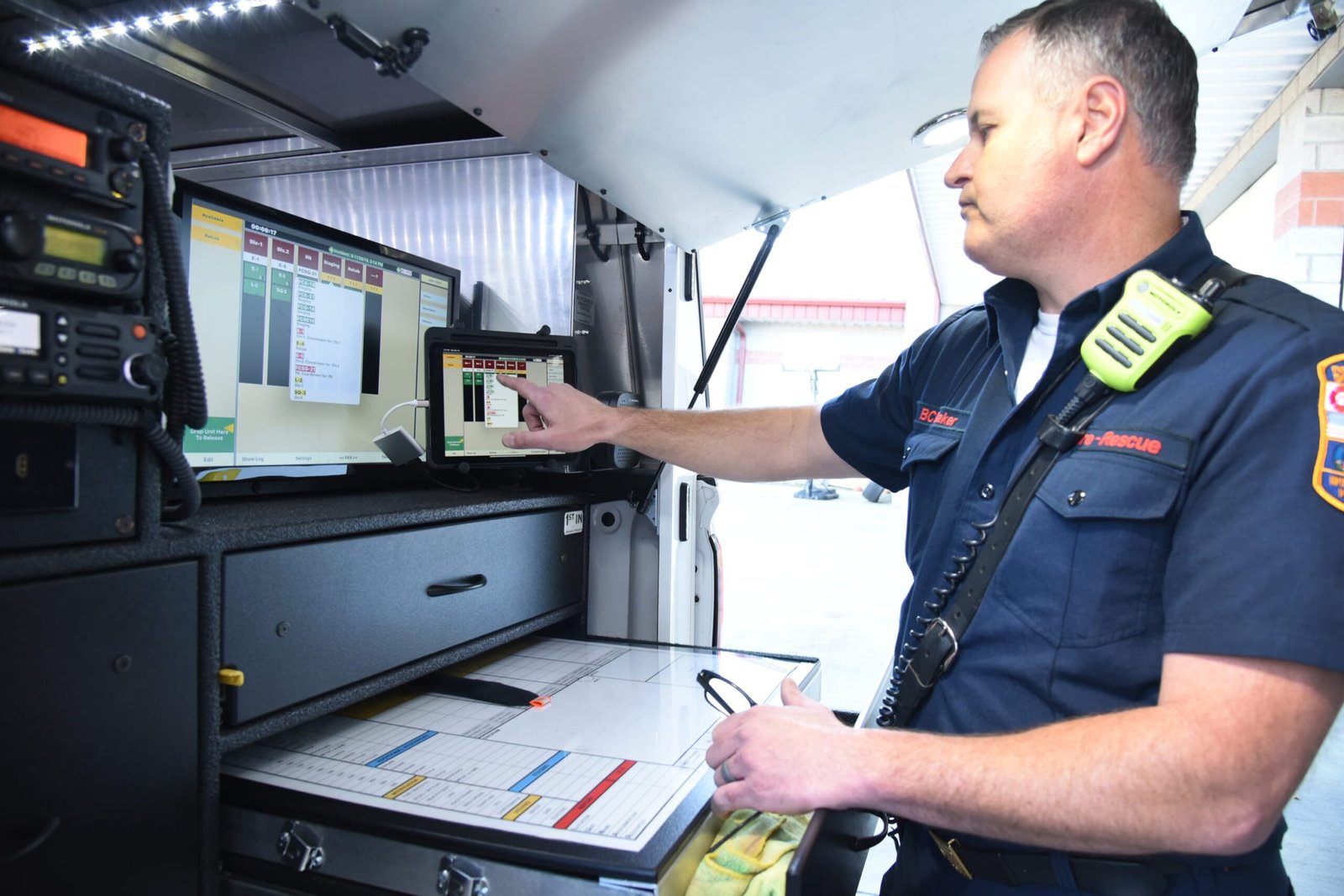
Dynamic Dashboards
The app provides interactive dashboards that display geotagged fire reports, weather data, and predictive risk maps. Each user — whether a volunteer, first responder, or decision-maker — receives a customized view. Risk areas are clearly color-coded, from green for low risk to red for high danger, while predictive overlays show how the fire may spread in real time.
Volunteer Coordination
A major strength of the platform is its volunteer mobilization capability. Through built-in task assignment and tracking, administrators can deploy observers, mitigators, and responders based on their proximity, training, and available resources. Integrated chat tools connect local teams directly to central command, ensuring civilian volunteers and professional responders work as a unified force.
Resource Management
The app also serves as a logistics oversight system. It tracks the status and location of pre-positioned equipment caches, issuing alerts when supplies are accessed or depleted. This transparency allows for rapid resupply and prevents shortages during critical operations. By minimizing logistical blind spots, the app strengthens resilience in high-pressure wildfire scenarios.
By combining real-time intelligence, volunteer coordination, and resource management, the cellphone application transforms a smartphone into a tactical command hub. It ensures that everyone involved — from local volunteers on the fireline to regional decision-makers — operates from the same shared picture, enhancing speed, cohesion, and overall effectiveness in wildfire response.
2. Intelligence, Surveillance, and Reconnaissance (ISR) Inputs
The wildfire response app enhances decision-making by integrating real-time ISR (intelligence, surveillance, and reconnaissance) data from IoT devices, drones, and satellites. This fusion of digital inputs creates a comprehensive operational picture, allowing both volunteers and professionals to respond quickly and effectively.
IoT Sensor Network
Low-cost IoT sensors form the backbone of early warning and fire monitoring. Devices such as weather meters, smoke detectors, and heat sensors are deployed in high-risk areas to provide continuous data on temperature, humidity, wind speed, and air quality. Using mesh networks or cellular connections, this information is transmitted to the app’s backend, where it is aggregated and analyzed in real time.
Drone Integration
The platform also leverages drone technology to validate reports and expand situational awareness. Drones equipped with thermal imaging and AI-powered detection systems can be launched autonomously or by trained volunteers. Their live feeds are ingested into the app, delivering real-time imagery of fire perimeters, hotspots, and inaccessible terrain. This capability allows responders to deploy resources more effectively while maintaining safety in dangerous environments.
Satellite Data
For large-scale fire tracking, the app incorporates satellite imagery. Advanced image-processing algorithms detect hotspots and map fire progression, complementing local ISR inputs. By layering satellite data over IoT and drone feeds, the system provides a comprehensive view of wildfire behavior at both the macro and micro levels.
Fixing and Ingesting Data
All incoming data — geotagged reports, IoT sensor inputs, drone imagery, and satellite feeds — is validated by the app’s AI-powered backend. Conflicting or redundant data is flagged for review, while verified inputs are fixed to precise GPS coordinates and displayed on the command dashboard. This ensures responders are working with accurate, real-time information.
By combining IoT devices, drones, and satellite imagery, the wildfire app transforms ISR data into actionable intelligence. The result is a living map that improves situational awareness, reduces uncertainty, and enables faster, more effective wildfire response.
3. Mass Notification and Mobilization
The wildfire response app transforms emergency communication by providing instant notifications to everyone involved, from individual citizens to entire communities. By combining automated alerts, volunteer activation, and evacuation support, it ensures that critical information reaches the right people at the right time.
Real-Time Alerts
The system delivers automated alerts on new fire activity, shifting weather conditions, and official evacuation orders. Each notification is customized by user role and location to ensure clarity and relevance. To maximize reach, alerts are pushed across multiple channels, including app notifications, SMS, and email, reducing the risk of missed updates.
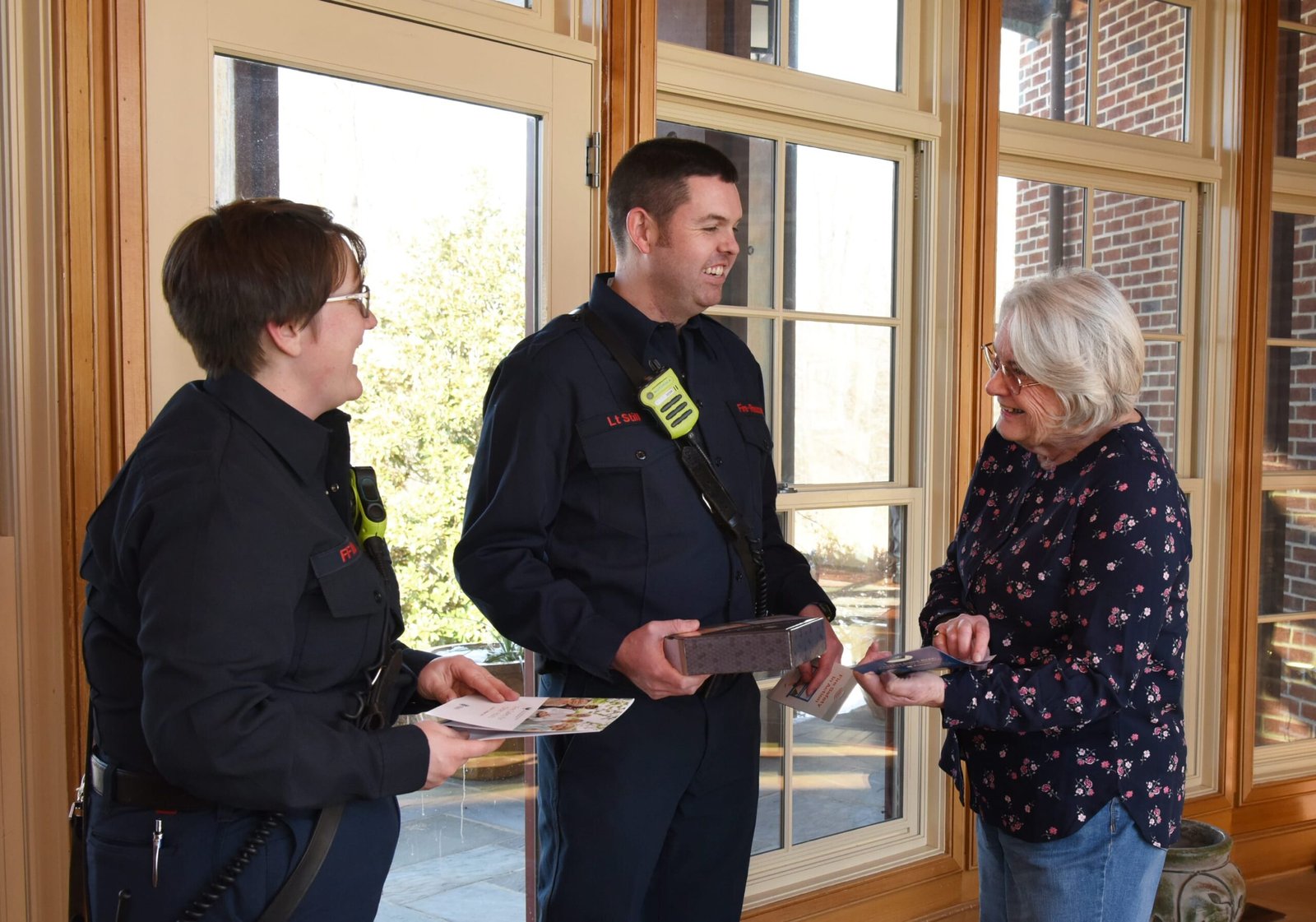
Volunteer Activation
The platform also serves as a hub for mobilizing civilian volunteers. Users receive task-specific notifications, such as confirming smoke sightings, clearing firebreaks, or deploying pre-positioned tools. A built-in gamified tracking system recognizes individual contributions with badges and community acknowledgments, encouraging sustained participation and reinforcing collective responsibility.
Evacuation Guidance
When evacuation becomes necessary, the app provides dynamic routing tools that adapt in real time. Routes account for predicted fire spread, road closures, and current traffic patterns to guide users toward the safest exits. Special alerts prioritize vulnerable populations, including seniors and people with disabilities, ensuring equitable and effective evacuation support.
By integrating real-time alerts, volunteer mobilization, and tailored evacuation guidance, the wildfire response app elevates emergency management to a new level. It not only informs but also empowers communities, turning passive recipients of warnings into active participants in wildfire resilience.
Enhancing Professional Firefighting Efforts
The decentralized wildfire response framework is not designed to replace professional firefighting agencies but to strengthen their operations through community support and advanced data integration. By connecting citizen inputs with professional expertise, the system creates a more adaptive and resilient wildfire response network.
Strategic Allocation of Resources
Through early detection tools — such as citizen geotagging and ISR inputs — professional teams receive timely intelligence on emerging hotspots. This allows firefighting agencies to prioritize high-risk zones and deploy aircraft, trucks, and personnel more efficiently. Predictive modeling within the app further optimizes resource use, ensuring maximum impact with limited assets.
Streamlined Communication
The platform provides two-way communication channels between professionals and the public. Agencies can issue real-time updates to communities while also leveraging citizen reports for tactical planning. This integration reduces blind spots and improves coordination on the ground.
Data Sharing and Intelligence Fusion
By consolidating IoT data, drone feeds, satellite imagery, and citizen reports, the app delivers actionable intelligence to professional responders. Instead of fragmented inputs, firefighting agencies gain a comprehensive view of the wildfire landscape, helping them anticipate spread patterns and adjust tactics proactively. This intelligence fusion approach draws on the same principles that underpin effective information operations in irregular conflict environments.
By enhancing resource allocation, improving communication, and centralizing data, this framework acts as a force multiplier for professional firefighting. It enables experts to work faster, smarter, and with greater situational awareness — while harnessing the power of community-driven resilience.
Comparing Response Models
The table below contrasts traditional centralized wildfire response with the decentralized framework proposed in this article across six critical operational dimensions.
| Dimension | Traditional Centralized | Decentralized Framework |
|---|---|---|
| Detection | Satellite imagery, fixed camera networks, 911 calls — relies on professional monitoring | AI cameras + citizen IoT sensors + geotagged app reports — layered, distributed detection grid |
| ISR | Professional aircraft and agency drones — limited availability, deployment delays | Citizen drone operators + IoT + satellite fusion — faster initial coverage, continuous feeds |
| Coordination | Incident Command System (ICS) — effective but scaling bottleneck with multiple simultaneous fires | App-based C2 layer supporting ICS — command center manages auxiliaries, transfers authority on professional arrival |
| Citizen Role | Passive — receive evacuation orders, report fires via 911 | Active auxiliaries — trained drone ops, firebreak teams, evacuation support, ISR contributors |
| Evacuation | Mass alerts via WEA/Nixle — inconsistent reach, static routing | Dynamic app-based routing + volunteer door-to-door assistance — adaptive, targeted |
| Scalability | Constrained by budget, staffing ceilings, and equipment procurement cycles | Grows with community enrollment — modular app architecture adapts across regions |
Actionable Takeaways
The decentralized wildfire framework offers a clear roadmap for implementation. By combining technology, community mobilization, and professional partnerships, it provides a scalable model for wildfire resilience.
Build the Application Framework
The first step is to design a wildfire response app that integrates geotagging, ISR inputs, and mass notifications. A modular architecture allows the platform to scale across regions, adapting to local needs while maintaining core functionality.
Deploy IoT and Drone Networks
Next, communities should establish IoT sensor networks in fire-prone areas, deploying low-cost devices that track heat, smoke, and weather conditions. Volunteer training in drone operations adds a rapid validation tool, ensuring that reports are accurate. Strong data-validation protocols must be in place to preserve reliability and prevent misinformation.
Establish Pre-Positioned Caches
Another critical measure is to pre-position firefighting caches strategically, using historical fire data to guide placement. These caches — containing tools, protective equipment, and supplies — can be maintained through partnerships with local businesses, ensuring readiness and sustainability.
Foster Collaboration with Professional Agencies
Finally, resilience depends on integration with professional firefighting agencies. Data-sharing agreements and interoperability standards ensure that volunteers and professionals operate from a unified picture of the fire environment. Volunteer training should focus on complementing, not replacing, professional teams, creating a layered defense against wildfire threats. For more on how structured civilian networks integrate with professional security forces, see TRH’s analysis of protecting critical infrastructure.
By combining app-based coordination, IoT and drone networks, pre-positioned resources, and professional collaboration, communities can move from reactive firefighting to proactive wildfire resilience.
Recommendations
The increasing frequency and severity of wildfires demand a transformative approach that empowers communities, bolsters professional firefighting capabilities, and actively involves the stakeholders most impacted. This framework, anchored by a robust cellphone application, represents a scalable, sustainable solution to wildfire management. By integrating advanced ISR inputs, enabling real-time communication, and mobilizing local volunteers, the system creates a resilient network where those directly affected by wildfires play a central role. Their participation enhances response times, minimizes losses, and ensures solutions are both practical and deeply rooted in the community’s needs, ultimately protecting people and ecosystems more effectively. The social network dynamics that make decentralized movements effective in conflict environments apply equally here — the strength of the framework scales with the density and training of its participant network.
Sources
This framework draws on research and reporting from multiple federal agencies and policy organizations. The National Cohesive Wildland Fire Management Strategy provides the foundational analysis of wildfire challenges and opportunities at the national level. The U.S. Department of the Interior’s wildfire challenges briefing outlines the scale of the federal response burden, while the RAND Corporation’s January 2025 commentary argues the LA fires demonstrated an urgent need to rethink centralized wildland firefighting systems.
On the technology side, ALERTCalifornia documents the deployment and effectiveness of AI-driven camera networks for wildfire detection across the state. The Firewise USA program (administered by NFPA) provides the community-level preparedness model that complements this framework’s citizen auxiliary concept. StateTech Magazine’s reporting on firefighting drones covers how local governments are integrating UAV technology into their response capabilities, and NIST’s ongoing wildfire evacuation and sheltering research (the ESCAPE framework) provides critical guidance on community-level evacuation planning.
The U.S. Government Accountability Office’s June 2025 testimony before the House Committee on Natural Resources offers the most comprehensive federal assessment of wildfire management technologies — including satellites, drones, AI-powered cameras, and IoT sensors — and their integration challenges.
Protecting Critical Infrastructure from Sabotage →
Reconnaissance: Methods and Applications →
Resistance Mobilization: Building Networked Movements →
Understanding Human Networks: Social Network Analysis →